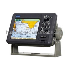
Kp 628f Gps Plotter Combo With Fish Finder - China
price: contact company for price
Matsutec
MODEL: KP- 628F KP- 828F KP- 1228F
COLOR LCD GPS Plotter combo with Fish finder
FEATURE:
1 High Resolution
1) KP- 628F: 5.6 inches Color TFT Display, 640* 640 pixels
2) KP- 828F: 8 inches Color TFT Display, 800* 600 pixels
3) KP- 1228F: 12 inches Color TFT Display, 800* 600 pixels
2 - 8 Color or 8 Level Amber Presentation
3 - 50/ 200 KHz Transceivers, Output Power:
1) KP- 628F 300 Watt
2) KP- 828F 600 Watt
3) KP- 1228F 600 Watt
4 - Blue, Light Blue, or Black Background Color
5 - 8 Range Scales, from 0- 15 to 0- 1000 Feet
1) HP- 628F from 0- 10m to 0- 600m
( Max: 3000ft, 500f, 600pB)
2) HP- 828F from 0- 10m to 0- 1000m
3) HP- 1228F from 0- 10m to 0- 1000m
6 - Range Offset to 0- 100 meters
7 - Automatic Range and Grain Selection Mode
8 - A- Scope Display for Rapid Fish ID and Detection
9 - Multiple Display Modes:
- Single or Dual Frequency
- Bottom Zoom
- Bottom Lock Expansion
- Maker Zoom
- Navigation Data Screen
- A- Scope
10 - Digital Display of Speed, Depth, Water Temp and Position
11 - Adjustable Bottom or Fish Alarm
12 - Calibration in Feet, Fathoms or Meters
13 - Built- in Picture Simulator
14 - SD- cards slot for C- Map and user data
15 - C- Map MAX and K- Chart Selectable
16 - Tide table and Celestial
17 - Versatile Display Mode Include
- Plotter Screen
- Plotter + Sounder
- Sounder
- Nav.
Data
- Satellite Information
- AIS Display
- Compass Screen
- Wind Screen
18 - GOTO track navigation
19 - MAP orientation select
20 - Proximity waypoints alarms
21 - Perspective View
22 - MAP Palette
- Normal
- Daylight – exposed to sunlight
- Night – in dark environment
- NOAA – paper chart colors
SPECIFICATION
PLOTTER CHARACTERISTICS
1 - Waypoints/ Icons: 14, 000 waypoints with name, symbol, 10 proximity waypoint.
2 - Route Memory: waypoint up to 169 points each, plus MOB and Track Navigator or Goto Track modes
3 - Tracks: 21, 000 points automatic track log; 15 saved track ( up to 2100 track points each) Let you retrace your path in both directions
4 - Alarm: XTE, Anchor Drag, Arrival, Speed, Voltage, Proximity, Waypoint and Time, AIS alarm.
5 - Palette
- Normal
- Daylight: Exposed to sunlight
- Night: In dark environment
- NOAA Paper chart color
6 - Tides: Tide Data
7 - Projection: Mercator projection
8 - Position format: Lat/ Lon
9 - Base Map: Built- in ONWA K- Chart
10 - External Map: SD cards slot for user settings
11 - User data storage: Internal backup of user settings, or external SD- card
12 - Plot Interval: 1s to 99h or 0.01nm to 9.99nm
13 - Polotting scales: 0.01nm to 1, 000nm
14 - Nav Data Input/ Output:
- Input:
$- - BWC, $- - BWR, $- - DBT, $- - DPT, $- - GGA, $- - GLL, $- - HDG, $- - HDM, $- - HDT, $- - MDA, $- - MTW, $- - RMA, $- - RMB, $- - RMC, $- - TLL, $- - TTM, $- - VDR, $- - VHW, $- - VTG, $- - WPL, $- - ZDA
- Output:
$- - AAM, $- - APB, $- - BOD, $- - BWC, $- - GGA, $- - GLL, $- - RMB, $- - RMC, $- - VTG, $- - XTE, $- - ZDA
- Output for autopilot:
$- - AAM, $- - APB, $- - BOD, $- - VTG, $- - DBT, $- - DPT
15 - PERSPECTIVE VIEW: On/ off
ECHO SOUNDER
1 - Echo Color 8 colors ( including background color) according to echo intensity.
Monochrome display is also available.
The background color is selectable from blue, light blue, white and black.
1 - Basic Range Meters: 10/ 20/ 40/ 80/ 150/ 200/ 300/ 500/ 1000
( for HP- 628F, up to 600m)
Feet: 30/ 60/ 120/ 200/ 400/ 600/ 1000/ 1600/ 3000
( for HP- 628F, up to 1500ft)
Fathoms: 5/ 10/ 20/ 40/ 80/ 100/ 150/ 250/ 500
( for HP- 628F, up to 200fa)
Passi/ Braza: 6/ 20/ 30/ 50/ 100/ 150/ 200/ 300/ 600
( for HP- 628F, up to 300pB)
The basic ranges can be changed on the system menu.
1 - Range Shift Up to 1000 meters ( 3000 feet, 500 fathoms, 600 passi/ braza)
1 - Zoom Range Times 2, 3, 4 and 5 ranges
1 - Bottom Lock Expansion Range 5/ 10meters, 10/ 20feet, 2/ 5fathoms, 2/ 5passi/ braza
1 - Auto Mode Automatic adjustment of range and gain
1 - Display Mode High Frequency ( 200K) , Low Frequency ( 50K) , Dual ( 200K and 50K 1/ 2display on each) , Zoom ( 200K and 50K zoom) and A- scope Display
1 - Zoom Display Marker Zoom, Bottom Zoom and Bottom- lock Expansion
1 - Display Advance Speed Lines/ TX: Freeze, 1/ 8, 1/ 4, 1/ 2, 1/ 1, 2/ 1
1 - TX Frequency
2 - Power Output 50 and 200kHz ( alternately transmitted)
1) KP- 628F: 300W 2) KP- 828F/ 1228F: 600W
1 - Pulse- length/ TX rate
1 - Interface Rejecter
2 - Alarm Display End Depth( m) 5, 10, 20, 40, 80, 150, 300, 600, 1000
Pulse- Length( ms) 0.15, 0.15, 0.15, 0.25, 0.4, 0.7, 1.5, 1.5, 2.7, 3.6
TX Rate( pulse/ min) 750, 750, 750, 375, 187, 107, 50, 50, 30, 21
Rejects unwanted signals by comparing last and present echoes in strength
Fish and Bottom alarms, Temperature alarm ( sensor required)
GPS Receiver Characteristics
1 - Receiver: 50 parallel channel GPS receiver continuously Tracks and uses up to 50 satellites to compute and update your position
2 - Acquisition times: Cold start: 27 seconds average
Warm start: 27 seconds average
Hot start: 1 second average
3 - Update rate: 1/ second, continuous
4 - Accuracy: Position: <2.5 meters( 95% ) without S/ A
Velocity: 0.1 meter/ sec without S/ A
Time: ±100ns synchronized to GPS time
5 - Dynamics: Altitude: 50, 000m Max
Velocity: 500 m/ s
6 - Datum: Acceleration: 4g Max
7 - Interface: WGS 84 & Others
NMEA 0183 Input, RS232output
8 - Antenna: HA- 017
AIS interface
Data input: NMEA0183, RS232
Baud rate: 38, 400
Power Supply:
1) KP- 628F: 10.5 to 35VDC, current drain 1.0A at 12V
2) KP- 828F/ 1228F: 10.5 to 35VDC, current drain 2.5A at 12V
Physical
1 - Size:
1) KP- 628F: 224mm( H) * 151mm( W) * 89mm( D)
2) KP- 828F: 290mm( H) * 195.5mm( W) * 99.5mm( D)
3) KP- 1228F: 364mm( H) * 268mm( W) * 106mm( D)
2 - Weight:
1) KP- 628F: 0.9kg
2) KP- 828F: 2.43kg
3) KP- 1228F: 3.95kg
3 - Display:
1) KP- 628F: 5.6 inches Color TFT Display, 640* 480 pixels
2) KP- 828F: 8.0 inches Color TFT Display, 800* 600 pixels
3) KP- 1228F: 12.1 inches Color TFT Display, 800* 600 pixels
4 - Waterproofing: Display unit: IPX5;
Antenna unit: IPX6
3 - Temperature range: - 15°C to + 55°C ( Display unit) ;
- 25°C to + 70°C ( Antenna unit)
EQUIPMENT LIST ( Standard)
1 - Display unit
2 - Antenna unit with 10m cable
3 - Transducer
4 - Operator manual
5 - Installation materials and standard spare parts
Company Contact:
- Posted By: HUAYANG TECHNOLOGY (HK) Co.,LTD
- Phone: 8675583289123
- Address: Unit 601,Bldg#614,Bagualing Industry Area,Futian D, Shenzhen , China
- Email:

Published date: October 29, 2015
- Business Description: Huayang Technology (HK) Co., Ltd. is a professional marine electronics
company, we have professional sales team and quality products equipment,
the spirit of "innovation and development, integrity based " corporate
philosophy, strive to create a first Service platform.
Huayang Technology products include Marine Radar , GPS navigation, fish finder, GPS chart plotter , ECS , ECDIS , Auto Pilot , AIS , AIS Sart , Radar Sart , Satellite phone of Inmarsat , Satellite phone of Iridium , Dock station for Inmarsat Isatphone pro , etc .
Our products are mainly exported to Southeast Asia, North America and South America , and Middle Eest market .
Through 10 years of development, the company already has an R & D team of 20 people, and to the continuous development and innovation for our customers to develop more advanced navigational equipment.
Hua Yang Technology in the "innovation and development, good faith"concept, together with domestic and foreign counterparts in the field of marine electronic equipment continue to forge ahead, and dedication to provide the most complete marine electronics.
Related listings
-
 Hp 628a Marine Gps Ais Chart PlotterElectronics - GPS - HUAYANG TECHNOLOGY (HK) Co.,LTD - China - October 29, 2015 - contact company for price
Matsutec 5.6" Color LCD Marine GPS/ AIS chart plotter Model: HP- 628A FEATURE: 1. High resolution TFT day- view LCD display 2. SD- cards slot for C- map Max and user data 3. C- map Max and K- chart Selectable 4. Tide table 5. Versatile display modes ...
-
 Hp 628 Matsutec 5 7 Tft Lcd Gps Chart PlotterElectronics - GPS - HUAYANG TECHNOLOGY (HK) Co.,LTD - China - October 29, 2015 - contact company for price
Matsutec 5.7 TFT LCD GPS CHART PLOTTER MODEL: Hp- 628 FEATURE: 1. High resolution 5.7 inches day- view LCD display 2. SD- cards slot for C- map Max and user data 3. C- map Max and K- chart Selectable 4. Tide table 5. Versatile display modes including...
-
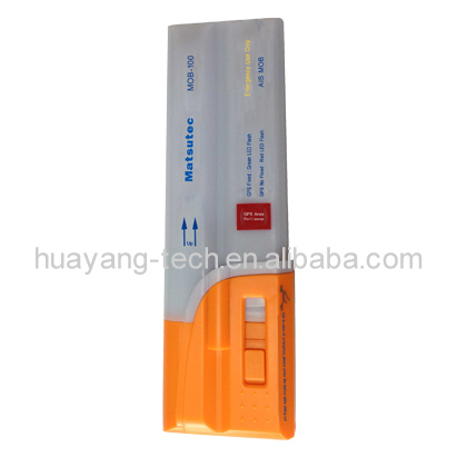 Mob 100 Ais Survivor Recovery SystemElectronics - GPS - HUAYANG TECHNOLOGY (HK) Co.,LTD - China - October 29, 2015 - contact company for price
MOB- 100 AIS Survivor Recovery System The MOB- 100 ( Survivor Recovery System) is a personal AIS ( Automatic Identification System) device designed to be fitted to a lifejacket and assist in Man Overboard recovery. It is lightweight, compact, and des...
Safe Trade Tips
- Ask for business references and check them
- Use a payment method that offers better protection for all such as Letters of credit and verified professional escrow services. Avoid payments in advance such as money transfers
- Verify their business via their local Chamber of Commerce
- Search the internet using their website address, their business name, their phone and fax numbers, and their email addresses to see if you can find any feedback about them.
- Get to know more about scams and fraud to avoid: Internet Crime Complaint Center - Consumer Financial Protection Bureau
- This site is never involved in any transaction, and does not handle payments, shipping, guarantee transactions, provide escrow services, or offer "buyer protection" or "seller certification"